Home › Explainers › Freezing level inside a cloud layer
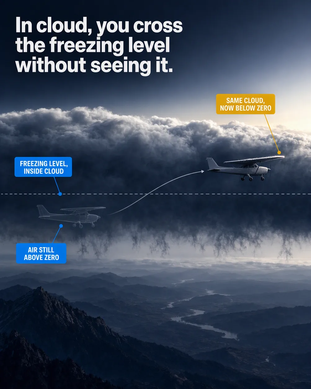
Cloud and sub-zero temperature are two separate conditions, and structural ice needs both, so the climb is the decision.
What the picture shows
The labels on the illustration, and what each one is pointing at.
- FREEZING LEVEL, INSIDE CLOUDThe thin dashed zero-degree line where it runs through the middle of the cloud layer.
- AIR STILL ABOVE ZEROThe ghost aircraft in the lower part of the cloud, below the freezing level.
- SAME CLOUD, NOW BELOW ZEROThe solid aircraft in the upper part of the cloud, above the freezing level, at its wing leading edge.
Why ice needs cloud and cold together
Picture a climb out through a solid overcast with the ground falling away. You are wet the whole way up, but moisture alone does not make ice.
Structural icing, the ice that builds on the outside of the airframe, needs two things at the same time. One is visible moisture, such as cloud or rain. The other is an airframe surface at or below freezing.
For the air, the handbooks are plain about it. The outside air temperature, or OAT, has to be below 0 °C for icing to happen. There is one exception, covered further down, because the airframe does not always match the air.
Ice matters because of what it does to airflow, far more than its weight. Frost or ice no rougher than coarse sandpaper on the leading edge or top of the wing can cut lift by 30 percent. That same thin layer can raise drag by up to 40 percent, and bigger buildups by 80 percent or more.
Where the freezing level hides in cloud
The freezing level is the height where the air temperature passes through 0 °C. Higher air is typically colder, which is why the handbooks list temperature and altitude together.
A cloud layer does not stop at the freezing level. One layer can straddle it, with its lower part in air above zero and its upper part in air below.
Climb through that layer and you cross the line while still inside the cloud. The moisture around you is the same before and after. Only the temperature changed, and the cloud gives no sign of it.
That makes the climb itself the decision. Below the line, the cloud supplies moisture and the air is above freezing. Above it, the cloud supplies both ingredients at once.
How cold the icing band usually is
Passing 0 °C does not mean more ice with every degree. Clouds hold supercooled water, liquid drops colder than freezing, and the colder the cloud gets, the less of it there is. Eventually only ice crystals remain.
That is why icing bunches into a band of temperature and height. High stratiform cloud colder than -20 °C is mostly ice crystals and gives little icing. The table shows where the reports gather.
Temperature also shapes the kind of ice. Rime, the rough milky kind, tends to form colder than -15 °C, and mixed ice forms between that and -10 °C. Clear ice, glossy and hard to see, tends to form warmer than -10 °C.
So the first degrees past the freezing level are clear ice territory. The handbooks call this general guidance, since drop size, water content and the aircraft itself change the result.
| Band | What the handbooks report |
|---|---|
| 0 °C to -20 °C | Almost all icing |
| -8 °C to -12 °C | About half of all reports |
| Near 10,000 ft | Peak of occurrence |
| 5,000 ft to 13,000 ft | About half of incidents |
| -40 °C | The only physical cold limit, where liquid drops freeze on their own |
When the airframe is colder than the air
Say you have been flying in cold air and then descend into air above 0 °C. The airframe does not warm up to the air temperature straight away.
This is called cold soaking. A cold-soaked airframe can stay below 0 °C for some time, and on some aircraft it stays that cold even after landing.
Aircraft with fuel tanks mounted flush to the skin are especially prone to this. They can pick up ice in air only slightly above 0 °C.
So an OAT reading just above zero is not a clean bill of health in cloud. How long an airframe holds the cold varies from type to type, so know your own aircraft's limits.
Why the top of a layer ices most
Flat, layered cloud is called stratiform. In low and middle stratiform layers, icing on average sits in a band 3,000 to 4,000 ft thick, and it usually runs from trace to light.
The strongest icing in these layers is in the upper part of the cloud. In a climb where the freezing level sits mid-layer, that upper part is exactly where you arrive after crossing it.
The shallow band helps you. A change of only a few thousand feet may take you out of the icing, even while you stay in cloud. The catch is that these layers spread a very long way sideways.
Heaped cloud, called cumuliform, is built differently. Its icing is narrower but taller, and in a building cloud it runs through every level above the freezing level. It is worst near the top, where the updraft is concentrated.
When descending does not get you out
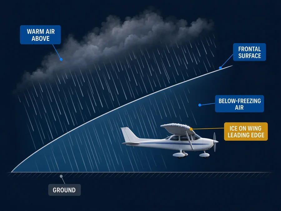
Going down to warmer air has a trap near fronts, which is where most icing reports come from. Under a front, air above freezing can sit on top of a layer below freezing.
Rain forms up in the warm air and falls into the cold layer underneath. The drops cool below freezing but stay liquid, which makes them supercooled. They freeze the moment they strike an aircraft.
This is a favoured spot for severe clear icing, because there is so much supercooled water. If the cold layer is shallow, the rain reaches the ground as freezing rain. If it is deep, the drops freeze into ice pellets, and ice pellets mean icing above.
Freezing rain often covers a broad area. With the cold air underneath you, a pilot may be unable to escape it by descending.
What to do when ice starts
Whatever ice protection your aircraft has, the first move is to leave the visible moisture. That could mean descending below the cloud bases, climbing above the tops, or turning onto a different course.
If none of those is possible, move to an altitude where the temperature is above freezing. Under freezing rain that may not work, and near mountains the terrain may stop you from descending to it.
Ice also feeds itself once it starts. Adding power and raising the nose to hold altitude increases the angle of attack, and that lets ice collect on the underside of the wings and fuselage.
What this teaches
- Structural icing needs visible moisture and an airframe surface at or below freezing, and a cold-soaked airframe can be below freezing in air that is not.
- A climb through a cloud layer can cross a freezing level inside the cloud.
- Below a front, rain from warmer air above can fall into below-freezing air, become supercooled, and freeze on impact with an aircraft.
- Icing in freezing precipitation often covers a broad area, and a pilot may be unable to escape it by descending.
Where to read more
Everything above rests on these. They are the FAA's own publications, free to read.
- Aviation Weather Handbook (FAA-H-8083-28), Chapter 20see Chapter 20
- Advisory Circular 00-6B, Aviation WeatherFAA advisory circular
Keep reading
- Pilot guideHow to Read a TAF
- Free toolCloud Base Calculator
- Pilot guidePersonal Minimums: How to Set Yours

Score the next flight before you go
FlightDecide reads the weather, the NOTAMs, your fuel and your weight and balance for the planned window, then scores them into a go / no-go call you can check against the raw data.
Get FlightDecide on the App StoreEducational content for pilots. It is advisory only and not a substitute for an official weather briefing, your POH, or your own judgment as pilot in command (14 CFR 91.3). The sources this explainer rests on are listed above.