Home › Explainers › Rotor cloud under a mountain wave
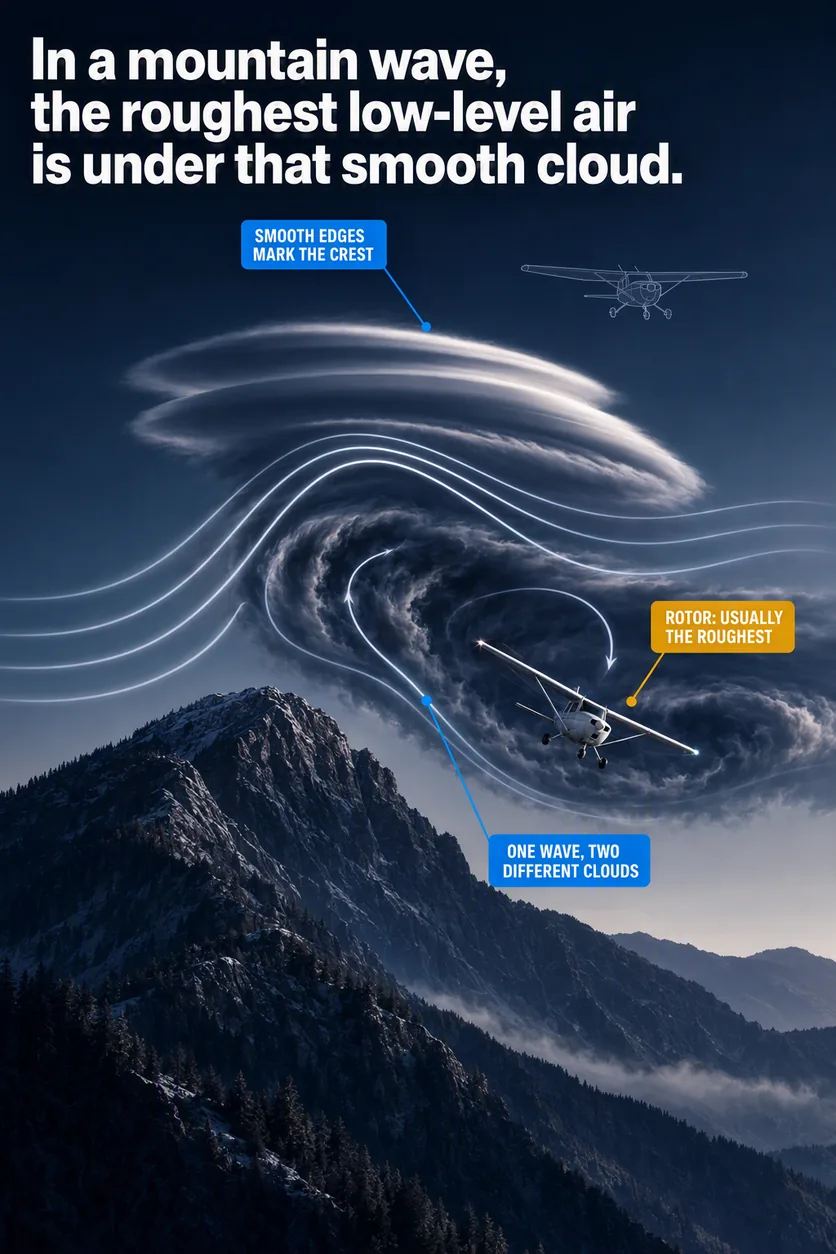
The smooth lenticular above and the ragged rotor below belong to the same wave, and down low the rotor is where the turbulence lives.
What the picture shows
The labels on the illustration, and what each one is pointing at.
- SMOOTH EDGES MARK THE CRESTThe hard lit upper lip of the stacked lenticular cloud at the wave crest.
- ROTOR: USUALLY THE ROUGHESTThe dark torn belly of the rotor cloud rolling directly beneath that lenticular.
- ONE WAVE, TWO DIFFERENT CLOUDSThe streamline that runs unbroken from the lenticular crest down into the rotor roll.
How a ridge sets the air waving
Picture a strong wind blowing across a mountain ridge on a stable day. Stable air resists being lifted, because once it is pushed up it is heavier than the air around it.
After the air clears the top of the ridge, gravity pulls it back down. Momentum carries it below its starting level, and compression warms it as it sinks, until it is lighter than the air around it. Up it goes again, overshoots again, and keeps bobbing downstream until the motion dies out.
That train of rises and falls is a mountain wave, and its high points are its crests. Air climbing toward a crest cools as it expands. With enough moisture, its water vapor condenses into cloud.
The cloud at a crest is a lenticular, named for its lens or airfoil shape. Lenticulars often line up in fairly straight bands parallel to the ridge but downwind of it, with clear sky between. Each band sits on a crest, so a row of them draws the wave for you.
What a lenticular's edges tell you
The edges of a wave cloud give you a clue to the air inside it. Smooth, laminar edges and tops, meaning they look sleek and layered, go with little or no turbulence.
A lumpy, uneven cloud says the opposite. So does any sense that it is rolling around an axis running along the cloud. Lenticulars themselves can look either smooth or turbulent, so read each one on its own.
A smooth-looking lenticular layer can still be rough at the bottom. Inside the layer, the air typically runs from turbulent near its base to smooth near its top.
The wave also roughens the air at its crests and at its troughs, the low points between them. It moves strong wind up and down, which sharpens the wind shear, a sudden change in wind speed or direction over a short distance. Shear like that stirs up turbulence.
Why the air under the crest rolls
When a mountain wave is present, a rotor quite commonly forms on the downwind side of the mountain. A rotor is a horizontal roll of air that stays put, near or below ridge height, beneath a wave crest. With enough moisture, it shows up as a rotor cloud under the lenticular.
The rotor zone is an area of possibly severe to extreme wind shear and turbulence. Some references call shear severe when it shifts your airspeed by more than 15 kt. They also count a change in vertical speed of more than 500 feet per minute, or fpm.
The roughness comes with big changes in the wind below cloud level. Just downwind of the mountains, a strong shear layer often sits near the cloud base. It splits a turbulent wake below mountaintop height, the churned air behind the mountain, from the faster air above that carries the cloud.
The wind beneath lenticulars can swing and gust a lot, but it is usually not extremely strong. Pilots flying near these clouds often report moderate to severe turbulence underneath them.
Those cloud bases typically sit one to several thousand feet above ridge level. The rotor turns lower, near or below the ridge, and at that level it is usually the most turbulent part of the wave.
Where the downslope windstorm ends
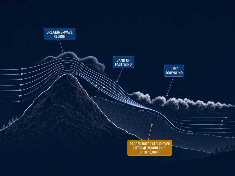
Rotors typically sit at the far end of a downslope windstorm. That is strong wind racing down the lee slope, the downwind side of the mountain, after the wave breaks high above. Gusts on those slopes can reach 100 kt.
That fast flow does not fade out gently. It often stops abruptly, some distance down the lee slope or well downwind of the mountains, and that stopping place is called the jump. When a rotor marks the end of the windstorm, it belongs to the jump itself.
Extreme turbulence often fills the jump, stretching 10,000 ft or more above the ground. A line of ragged rotor clouds sometimes marks it. Beyond the jump the air calms somewhat, but the turbulence can still be strong.
How to spot a rotor cloud early
A rotor and its cloud are usually spinning hard. From a moving airplane, though, you may not see the spin until you are quite close.
From far off, a rotor cloud can pass for a harmless cumulus, the billowy cloud of a sunny afternoon. Look at its downwind side. It is typically rounded in the direction the rotor turns.
Then look along the bottom for ragged tags or streamers of cloud. They seem to form and vanish quickly, and that flicker is what gives you a sense of the spin inside.
What a rotor does to your airplane
The advice on rotor zones is to stay out of them. Strong turbulence is likely around a rotor, most of all on its upwind side.
The spinning air can also produce rolling moments, forces that bank the airplane, stronger than your controls can counter. That can end in a loss of control.
Low altitude is where a rotor is most dangerous, and takeoff and landing top the list. You are slow then, and the airplane is set up for relatively high drag.
Close to the runway in mountain winds, local gusts above 50 kt are possible, with downdrafts greater than 1,500 fpm. A downdraft can sink you faster than your airplane can climb. Airplanes with high wing and power loading, meaning lots of weight for their wing and engine, are most exposed.
| Where | What | Figure |
|---|---|---|
| Wind flow at ridge level | Suspect disturbances downwind of rugged terrain | exceeds about 20 kt |
| Lee slopes | Downslope wind gusts | 100 kt |
| Jump region | Extreme turbulence | 10,000 ft or more above the surface |
| Takeoff and landing | Localized gusts | in excess of 50 kt |
| Takeoff and landing | Downdrafts | greater than 1,500 fpm |
When the wave leaves no clouds
Lenticulars and rotor clouds need enough moisture in the air arriving at the mountain. Mountain waves often come with them, or with blowing dust. That is not always so, and extremely severe winds can arrive with little or no visual warning.
So a clear sky downwind of a ridge does not mean there is no wave. Trapped lee waves, waves whose energy stays below a certain height, frequently occur without any cloud.
Watch the wind instead. Suspect hidden disturbances whenever you fly downwind of rugged terrain with ridge-level wind above about 20 kt. That figure is the prevailing wind at the ridge crest, upwind of you, not a local gust.
Fly low over mountains with 20 kt or more at ridge level and you can expect moderate or greater turbulence. You can also expect strong updrafts and downdrafts, and very strong rotor and shear zones. That holds most of all for general aviation airplanes, the kind you likely train in.
The worst mountain wind events tend to fall between late autumn and early spring, when the big weather-map winds blow hardest. In a wave flow, fly at turbulence penetration speed, the speed meant for rough air. Stay clear of terrain that drops away sharply, even with no lenticular in sight.
What this teaches
- A mountain wave can form smooth lenticular cloud at its crests and turbulent rotor cloud beneath them.
- At low level the rotor beneath the crests is usually the most turbulent part of the wave.
- A mountain wave is often marked by lenticular and rotor clouds, but extremely severe wave winds can occur with little or no visual warning.
Where to read more
Everything above rests on these. They are the FAA's own publications, free to read.
- Aviation Weather Handbook (FAA-H-8083-28), Chapter 16see Chapter 16
- Aviation Weather Handbook (FAA-H-8083-28), Chapter 19see Chapter 19
Keep reading
- Pilot guideHow to Read a TAF
- Free toolCloud Base Calculator
- Pilot guidePersonal Minimums: How to Set Yours

Score the next flight before you go
FlightDecide reads the weather, the NOTAMs, your fuel and your weight and balance for the planned window, then scores them into a go / no-go call you can check against the raw data.
Get FlightDecide on the App StoreEducational content for pilots. It is advisory only and not a substitute for an official weather briefing, your POH, or your own judgment as pilot in command (14 CFR 91.3). The sources this explainer rests on are listed above.