Home › Explainers › A temperature inversion trapping haze
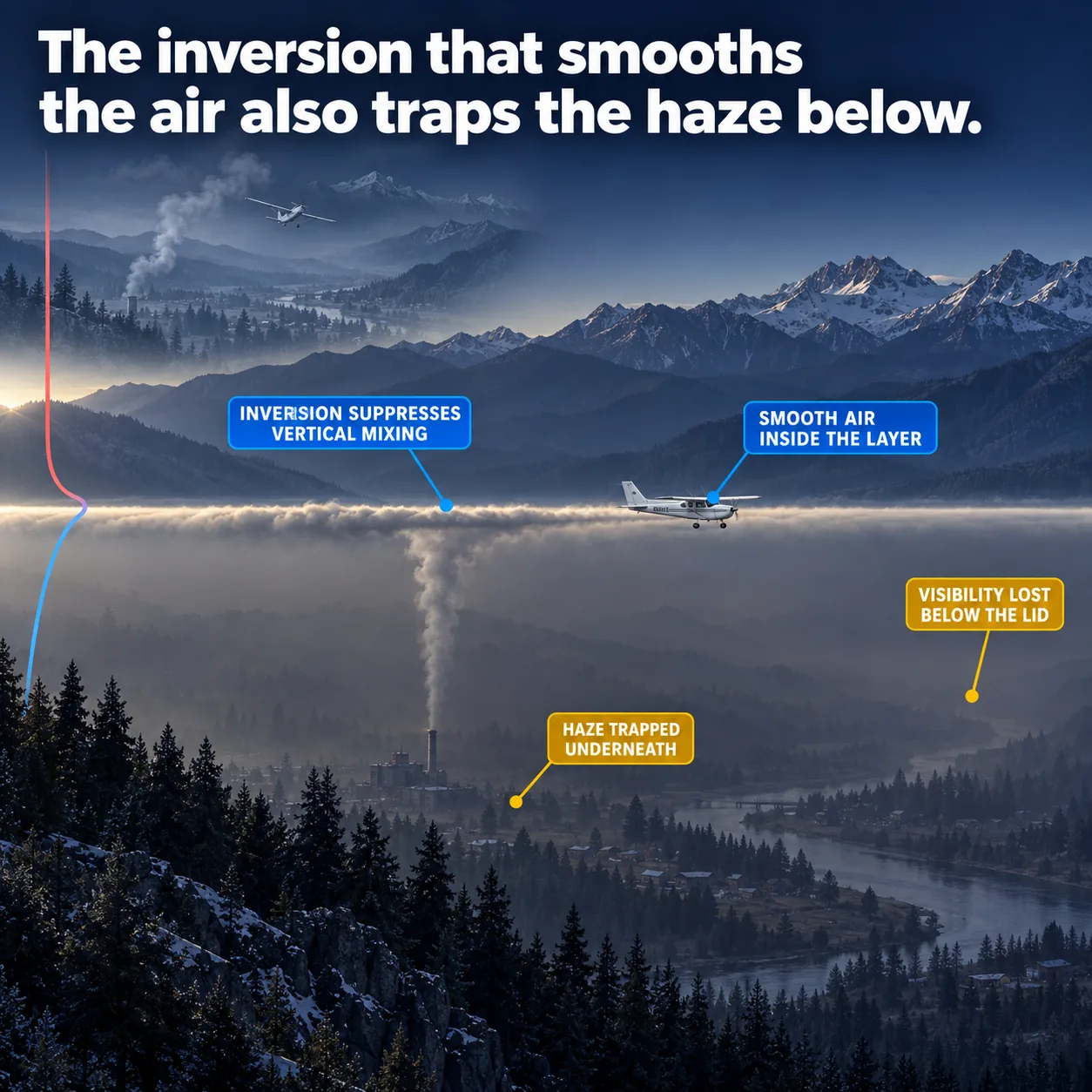
Smooth air and poor visibility arrive together, because the inversion that stops the mixing also traps what is in the air.
What the picture shows
The labels on the illustration, and what each one is pointing at.
- INVERSION SUPPRESSES VERTICAL MIXINGThe height where the rising smoke column stops climbing and spreads sideways into a level sheet.
- SMOOTH AIR INSIDE THE LAYERThe small profile aircraft flying wings-dead-level at the top of the haze, on the inversion line.
- HAZE TRAPPED UNDERNEATHThe dense amber-brown murk filling the valley floor beneath that line.
- VISIBILITY LOST BELOW THE LIDThe far end of the valley below the line, where the ridges dissolve into grey with no edges left.
The smooth ride with nothing to see
You climb out on a still morning and the air is glassy. There is no bump on the climb and the wings barely move. Yet the far end of the valley fades into a brown blur.
Those two things feel unrelated. One is good news for the ride and the other is bad news for finding your way. They come from the same layer of air, and once you see why, the pairing stops being a surprise.
That layer is called a temperature inversion. To understand it, start with what the air normally does as you climb.
Why air usually gets colder with height
Air that rises moves into lower pressure, so it expands. Expanding air cools, even though no heat has left it. Air that sinks does the opposite, getting squeezed and warmer as the pressure grows.
This warming and cooling from pressure change alone is called adiabatic heating and cooling. The rate at which temperature drops with height is called the lapse rate. The handbook puts the average at 2 °C (3.5 °F) per 1,000 feet.
A parcel of air, a single blob you imagine lifting, cools at its own rate as it rises. Dry air cools faster than moist air. The rates sit side by side in the table below.
| Air | Temperature change per 1,000 feet |
|---|---|
| Average atmosphere | Drops 2 °C (3.5 °F) |
| Rising dry (unsaturated) air | Drops 3 °C (5.4 °F) |
| Rising moist (saturated) air | Drops 1.1 °C to 2.8 °C (2 °F to 5 °F) |
| Inside an inversion | Rises with altitude |
What makes air keep rising or sink back
Picture nudging a parcel of air upward and then letting go. As it rises it cools, and you compare it with the air now around it. Colder air is denser, so a colder parcel sinks back to where it started.
If the parcel ends up warmer than its surroundings, it is lighter and keeps rising on its own. That is unstable air, where small upward pushes grow into bumps and building clouds. In stable air, small pushes die away instead.
The difference comes down to how fast the surrounding air cools with height. When it cools slowly, a lifted parcel soon ends up colder than its neighbours. The smaller the lapse rate, the more stable the air.
Why rising air stalls at the warm layer
Now take the extreme case. In an inversion, the air gets warmer as you climb instead of colder, up to a certain height. That height is the top of the inversion.
Lift a parcel into that layer and it cools while the air around it warms. It ends up colder and denser than its surroundings, so it sinks back. The handbook files inversions under absolute stability, where every lifted parcel returns to its level.
This is why the ride is smooth. Vertical mixing, the up and down stirring of air that you feel as bumps, has nothing to drive it. The handbook describes these layers as commonly shallow, smooth and sitting close to the ground.
Where the haze and smoke end up
Smoke, haze and other pollutants start near the surface. In unstable air, rising currents stir them upward through a deeper layer.
Under an inversion that stirring stops at the top of the layer. The warm air there works like a lid on a pot. Whatever is below stays trapped below it.
So the same stability that gives you a smooth ride also collects the haze. Visibility drops inside the layer, because what would have been carried upward is held in the shallow air near the ground.
Moisture adds to it. Relative humidity is how much water the air holds against the most it could hold at that temperature. When it is high, the trapped layer can also produce clouds, fog, haze or smoke.
Where inversions come from
The most common kind starts at the ground. On a clear, cool night the ground loses heat and chills the air touching it. Soon the air within a few hundred feet of the surface is colder than the air above.
That is a surface-based inversion. The coldest air sits at the bottom, which is exactly the arrangement that resists mixing. That is why the smooth, hazy air in the opening section is a morning scene.
A second kind forms at fronts. Warm air spreads over a layer of cooler air, or cooler air pushes in underneath warmer air. Either way you get warm air on top of cold.
The sun changes the picture through the day. Daytime heating of the surface raises the lapse rate and lowers stability, while nighttime cooling does the opposite. The swing is largest over land, under clear skies, in dry air and light wind.
What it means when you fly in it
Inside the layer, expect the ride to be smooth and the view to be poor. They are one state of the air showing up two ways. Treat a glassy ride as a prompt to look hard at visibility.
The top of the inversion is where things change. Climb above the lid and the haze lies below you as a level sheet. The reduced visibility the handbook describes belongs to the layer beneath.
Coming back down means descending into it again. Landmarks you picked out from above can fade once you sink under the lid, even though the air stays smooth the whole way.
What this teaches
- A temperature inversion is a stable layer that suppresses vertical mixing.
- The top of the inversion acts as a lid, trapping haze and smoke in the commonly smooth layer beneath it and reducing visibility there.
Where to read more
Everything above rests on these. They are the FAA's own publications, free to read.
- Pilot's Handbook of Aeronautical Knowledge (FAA-H-8083-25), Chapter 12see Chapter 12
- Aviation Weather Handbook (FAA-H-8083-28), Chapter 13see Chapter 13
Keep reading
- Pilot guideHow to Read a TAF
- Free toolCloud Base Calculator
- Pilot guidePersonal Minimums: How to Set Yours

Score the next flight before you go
FlightDecide reads the weather, the NOTAMs, your fuel and your weight and balance for the planned window, then scores them into a go / no-go call you can check against the raw data.
Get FlightDecide on the App StoreEducational content for pilots. It is advisory only and not a substitute for an official weather briefing, your POH, or your own judgment as pilot in command (14 CFR 91.3). The sources this explainer rests on are listed above.